Google Geocodes to Shapefile - Via Google Fusion Tables, Google Earth and ArcMap
This is a tutorial for what I hope to be (when bugs and flaws are ironed out) a way for the everyday GIS'er to Geocode a list of addresses to Shapefile - for free and with no writing code yay!
By the way, I do indulge in VBA and a bit of Python, but if I dont have to, I dont want to.. right!?
So stay with me, there are a lot of screenshots, so if in doubt, just follow them and drown out the white noise that is my narration :)
I will have to disclaim that I got this to work fine when I had two addresses in my table typed out perfectly, but since trying on a table that was given to me I've had things turn a bit pear shaped (ie rubbish in/rubbish out).
Please try this out, and leave comments about how it goes for you. I can't promise I can help at all, but would love to see what this can do!
So.. here goes
Step 1. Make a table
Use your poison of choice, make a table, this is MS Excel, you could use Google Docs seeing as this will be a googlefied project.
Mine has two columns, "Name" and "Location"
I have found that this method only gives you one attribute column at the end, so I would in hindsight have an ID column instead to join all the fun stuff back in once the geocoder had done its magic.
Step 2. Get/Sign up to Google Fusion Tables
Step 3. Import your table
Step 4. Geocode
Step 7. Import to Google Earth THEN Export to KML (yes, export to KML... again)
Output to Shapefile :)
So, good luck with this! Give it a go.. It is million times better than the mapping gadget on Google documents (as far as I can tell)
And, just cause I can't shut up right now.. this is also something that would be useful for blogs, websites etc, but go look up Google's terms of use before you go saying "But Mel said I could use it"
Back in the Google Fusion Tables there were some other things you could do with that original map, the "Get embeddable link" is great for those html style widgets you get on blogs etc.
Okay, now I'm done..
By the way, I do indulge in VBA and a bit of Python, but if I dont have to, I dont want to.. right!?
So stay with me, there are a lot of screenshots, so if in doubt, just follow them and drown out the white noise that is my narration :)
I will have to disclaim that I got this to work fine when I had two addresses in my table typed out perfectly, but since trying on a table that was given to me I've had things turn a bit pear shaped (ie rubbish in/rubbish out).
Please try this out, and leave comments about how it goes for you. I can't promise I can help at all, but would love to see what this can do!
So.. here goes
Step 1. Make a table
Use your poison of choice, make a table, this is MS Excel, you could use Google Docs seeing as this will be a googlefied project.
Mine has two columns, "Name" and "Location"
I have found that this method only gives you one attribute column at the end, so I would in hindsight have an ID column instead to join all the fun stuff back in once the geocoder had done its magic.
Step 2. Get/Sign up to Google Fusion Tables
Step 3. Import your table
Step 4. Geocode
Important! Make sure the "Column" is set to Location. One time this jumped to "Name" and things started acting weird.
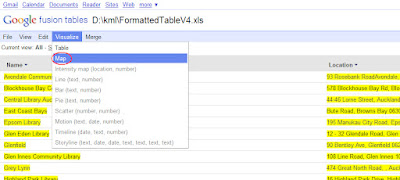
Step 5. Display in a map
Step 6. Export to KML
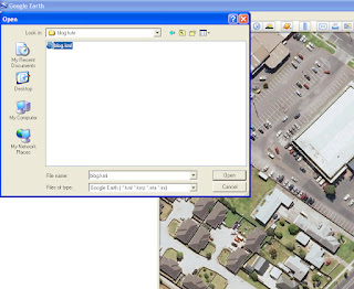
Step 7. Import to Google Earth THEN Export to KML (yes, export to KML... again)
Step 8. Download kml_to_shp tool from HERE
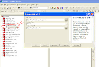
Step 9. Follow the instruction given with the tool to import the tool into ArcToolbox (ArcMap 9.2 or 9.3 only)
*If you google something like "KML to SHP" you'll come up other ways to do this, so please, if you have 9.1 or 3.x go and search for something to do this. I tried this Zonum tool early on, but maybe because my data was dirrrty it didn't work. Please try other tools out and let me know what works for you.
Step 10. Use the "Convert KML to SHP" tool!
Output to Shapefile :)
And, just cause I can't shut up right now.. this is also something that would be useful for blogs, websites etc, but go look up Google's terms of use before you go saying "But Mel said I could use it"
Back in the Google Fusion Tables there were some other things you could do with that original map, the "Get embeddable link" is great for those html style widgets you get on blogs etc.
Okay, now I'm done..


Well done!
ReplyDeleteI don't know about 9.3 but in 10 there are a few geolocators included that sit on arcgisonline. Not sure how useful it would be for NZ it worked ok for me here in Netherlands.
Awesome, can't wait to get my hands on 10 :) I'll keep that in mind, I was doing some of this research for a school who *might* be getting it.. Great to hear from you !!
ReplyDeleteThis is proving very helpful for me. Thanks for posting! I'm curious whether you have found that Google prompts you if it finds an issue with geolocating. For example, what happens if you have 123 Main St, and there are both 123 E. Main St and 123 W. Main St?
ReplyDeleteHi Tim, this post was from a little while back now, from what I understand about geocoding, is that its much like typing it in to the google maps website, the geocoding will take the first returned value from the address search. the only thing you can do is check the point and adjust your address query if it returns the wrong location, I dont remember it being that automated. one thing to note, is that google fusion tables are now integrated into Google Drive, the new version of Google documents.. I'm running Chrome internet browser so its all pretty seemless. Good luck with it!
Delete